As I've mentioned here before, a version of FalconView will soon be released to the general public as open-source software. This is exciting to me not only because the public will be able to contribute to the FalconView code base, but also because the public will be able to download, install and use FalconView. FalconView scales through charts and images better than any other GIS software I've tried, so I'm expecting that we will see widespread use beyond the our traditional defense community.
Some products do better than FalconView at some GIS tasks: Google Earth is an excellent tool for presenting 3D imagery; ArcGIS is the leading general-purpose GIS tool for advanced GIS users; Quantum GIS makes it easy to connect to PostGIS. FalconView started in the early 1990s before industry GIS standards were mature. Because FalconView development has been tailored to government needs, FalconView doesn't do a great job of interoperating with other GIS products. With the FalconView open-source release, Georgia Tech hopes to change this.
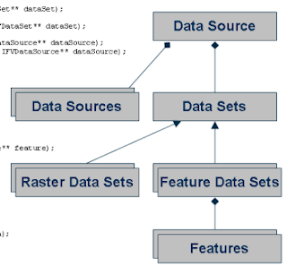
The public version of FalconView 4.3 will include a new common data architecture that more closely aligns FalconView with the industry standards published by the Open Geospatial Consortium. The data architecture arranges data sources in a format that will be familiar to ArcGIS and OGR users: data sources contain data sets, data sets contain features, and features have a geometry and fields. Geometries are defined per the OGC simple features specification.
The point of this common data architecture is interoperability. Using the architecture prototypes Georgia Tech has already demonstrated interoperability with PostGIS, WMS, KML and a few other formats. The KML functionality will be released with FalconView 4.3, and support for some other formats - WMS for one - will likely be included with other formats forthcoming.
This is exciting stuff. Hopefully we can continue to improve FalconView's interoperability with industry standards so that the product becomes a useful tool for a wide range of GIS applications. Here is a link to a slide show that we recently gave to the government to describe what we're doing. I'm sorry that the slides don't stand too well on their own, but hopefully they get the point across. If some of our architecture looks familiar, that's good: we're aligning with paradigms that experienced GIS users, analysts and developers are already familiar with.