Wednesday, September 30, 2009

FalconView and General Aviation

Georgia Tech just got the green light for making FAA / NACO sectionals for FalconView available for free download. You can get them on the Downloads tab of the FalconView web site.

As a commercial pilot, I'm interested in bringing the flight planning capabilities of FalconView to the general public. (I often use the software myself as an aid to preflight planning.) The main hindrance to this now is the availability of data on airports, navaids, waypoints and airspace. When I get a chance, I'll poke around some and see if I can find this data in a format that FalconView can read and that I won't go to jail for distributing. After that I'll post here a tutorial on ways that FalconView can be used as a flight-planning aid. In the meantime, I'd be glad to answer individual questions in the comments below. (There is also a thread in the discussion groups on the FalconView web site on using FalconView for general aviation.)

Keep a lookout on this blog for hints and tips that will help the general public use FalconView for the kinds of flight-planning tasks that our military has used it for for years.

[[ UPDATE: There is now a wiki page on the FalconView web site that should help pilots to get started with using FalconView for GA planning. ]]

Wednesday, July 29, 2009

Military Open Source Software Working Group Will Meet Aug. 12-13

ATLANTA -- The initial gathering of the Military Open Source Software (Mil-OSS) Working Group will take place here on Aug. 12 and 13 at the Georgia Tech Research Institute (GTRI) Conference Center. The group will discuss the role of open source software for military applications. This non-classified event is open to all interested parties. "People concerned with the future of open source software for the military are sure to find this meeting quite interesting," said Joshua L. Davis, a GTRI research scientist who is coordinating the gathering. "This is the working group’s first meeting, and our intention is to hold future meetings of this group every six months."

Keynote addresses will be given by Daniel Risacher, associate director of Information Policy and Integration, DoD CIO, and by Major James D. Neushul, I-MEF Future Operations, Commo / IMO. Risacher will speak on "Open Source and the U.S. Department of Defense"; Neushul’s talk is titled "Keep It Stupid Stupid: The KISS Principle for DoD Acquisitions."

Organizers plan an open agenda, with some 18 presentations scheduled thus far. In addition, there will be three tracks -- Geospatial OSS Projects, General OSS Projects, and Miscellaneous Topics. Registration cost for the gathering is $325 for attendees, $250 for speakers, and $100 for students, and special hotel arrangements are available. For complete information on registration, attendance and other topics, visit http://www.mil-oss.org/.

[[ Yes, FalconView will be there! ]]

Saturday, June 27, 2009

FalconView Open Source Hits the Web

Not only has Georgia Tech published the source code for FalconView 4.3, but we have also published Windows installer binaries for the full application. All of this and more can be found on the FalconView web site. Please keep in mind that FalconView 4.3 is still young. We haven't even reached the beta stage because we're still polishing features that will appear in 4.3. The current build is suitable for developers and for folks who want to evaluate the application.

There are a handful of features for FalconView that should make it useful for the general public. We still support Shapefiles, GeoTIFF, and other popular GIS formats. We have the drawing overlay and the analysis tools for making your maps more useful. Also, we now support Google Earth KML / KMZ and Web Mapping Servers. A list of features, along with screen captures can be found here. Oh, and did I mention that my prized GIS Editor along with its source code is included?

Feel free to contribute to the project by writing plugin extensions for FalconView or by submitting improvements to Georgia Tech. The SDK is available on the web site along with a handful of other developer resources and examples. I'm usually glad to answer quick question for someone interested in coding for FalconView.

Download it and take it for a spin; just treat it gently while we work out the kinks.

Thursday, March 12, 2009

FalconView Interoperability

As I've mentioned here before, a version of FalconView will soon be released to the general public as open-source software.  This is exciting to me not only because the public will be able to contribute to the FalconView code base, but also because the public will be able to download, install and use FalconView.  FalconView scales through charts and images better than any other GIS software I've tried, so I'm expecting that we will see widespread use beyond the our traditional defense community.

Some products do better than FalconView at some GIS tasks: Google Earth is an excellent tool for presenting 3D imagery; ArcGIS is the leading general-purpose GIS tool for advanced GIS users; Quantum GIS makes it easy to connect to PostGIS.  FalconView started in the early 1990s before industry GIS standards were mature.  Because FalconView development has been tailored to government needs, FalconView doesn't do a great job of interoperating with other GIS products.  With the FalconView open-source release, Georgia Tech hopes to change this.

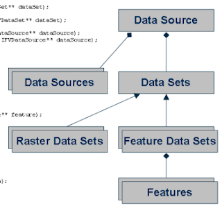
The public version of FalconView 4.3 will include a new common data architecture that more closely aligns FalconView with the industry standards published by the Open Geospatial Consortium.  The data architecture arranges data sources in a format that will be familiar to ArcGIS and OGR users: data sources contain data sets, data sets contain features, and features have a geometry and fields.  Geometries are defined per the OGC simple features specification.

The point of this common data architecture is interoperability.  Using the architecture prototypes Georgia Tech has already demonstrated interoperability with PostGIS, WMS, KML and a few other formats.  The KML functionality will be released with FalconView 4.3, and support for some other formats - WMS for one - will likely be included with other formats forthcoming.

This is exciting stuff.  Hopefully we can continue to improve FalconView's interoperability with industry standards so that the product becomes a useful tool for a wide range of GIS applications.  Here is a link to a slide show that we recently gave to the government to describe what we're doing.  I'm sorry that the slides don't stand too well on their own, but hopefully they get the point across.  If some of our architecture looks familiar, that's good: we're aligning with paradigms that experienced GIS users, analysts and developers are already familiar with.

Friday, February 13, 2009

New FalconView Web Site

In preperation for the upcoming FalconView open source release, Georgia Tech has launched a new web site for the FalconView project.  The new web site pulls together the main web site at falconview.org, as well as the developer wiki.  Check it out here.